วันจันทร์ที่ 13 กรกฎาคม พ.ศ. 2558

Srinakarin Dam

Srinakarin Dam


Details attractions:

Srinakarin Dam A tourist symbol of Kanchanaburi. Visitors to the dam to watch the third-largest dam behind. And Chao Phraya Dam And rockfill dam of clay core in Thailand. Tourists can visit the spectacular views on the dam throughout the year.

Srinakarin Dam The locals call it. "The dam will neophyte" House located in the Chao Nen. District board Si Sawat The dam is a clay core dam. Stone was raised over the top with cancer. Srinakarin Dam is a rockfill dam of the largest clay core. And the capacity in Thailand is 17,745 million cubic meters. Born in the reservoir area is 419 square kilometers. The dam is 140 meters high from the foundation dam 610 meters long, 15 meters wide dam is the first of its kind multi-purpose development project Mae Klong River. Reduce flooding in the basin of the river. A fish breeding The main benefit of fishermen and used to generate electricity. The generator 5 total capacity of 720,000 kilowatts of electricity per year to 1,250 million kWh.

Its construction began in the year 2516, completed in 2523 was named by the dam is Ban Chao Nen. After completion King HRH Princess Maha Chakri Sirindhorn and HRH The Princess Royal. He presided over the opening ceremony on 15 June 2524 and he graciously invited to the title the Princess Mother. The dam is named

The area around the dam is decorated. Beautifully adorned with many a musical garden Srinakarin. The water wheel is rotated forward to strum the notes are the same as in the music box. A roundabout is a remembrance garden. And planted flowers around nicely. You can drive up to the dam, to view a large reservoir. Surrounded by mountains The viewpoint is a natural beauty.

Facilities dam
Srinakarin Dam is open to visitors every day from 06:00 to 18:00 hrs. Dam also has a restaurant. Meeting rooms and cottages can rent a boat to explore the reservoir.

Contact details
Hospice Srinakarin Tel. 034-513001-2 to 245.

*** Tourists can stay in private accommodation on the edge of the reservoir. Many home made floating. The natural environment Some of the players in the water. Where visitors can swim along the reservoir was more fun. A kayak to paddle play in the reservoir. Some of the wet pad (Bamboo raft ride together to the tourists. Then take boat tours in different places) to tour the dam.

More information
The Electricity Generating Authority of Thailand Tel. 0 2436 6046-8.
Restaurant cruise Tel. 0 3457 4001 to 2455, 2457.


Getting to Srinakarin Dam
Bangkok - Srinakarin Dam 210 kilometers
Kanchanaburi - Srinakarin Dam 70 kilometers.

Car
- Kanchanaburi Road Runner Sangchuto a main road. Burr intersection rapids Directly Srisawat (Highway 3199) straight through the intersection grassy slope. Training camps, military students Golf New Ichigo temple Lemon Creek bridge to jump ship. (Start Srisawad district).
- Across the entrance to the Srinakarin Dam. Drive to the left of the road Along the river's tributaries through EGAT will find three separate runs to go up to the dam.

Buses between districts
- If a train from Bangkok Noi railway station. Or bus Bangkok - Kanchanaburi from the Southern Bus Terminal. Bus Terminal Or van monument Get off at Kanchanaburi
- Ride from the bus station in downtown Kan. Go into the market Srinakarin Contractors hired the taxi to take them to visit the dam and the surrounding area.

Pha heaven

Pha heaven


Details attractions:

Pha heaven As one of the larger waterfalls. And very beautiful Deep in the forest, the natural fertility. Filled with dense trees surrounding. In addition to the great beauty of the waterfalls that attract people to find. The path to heaven Pha Is another exciting challenge. People who like adventure Overcome Difficulties Foreign wanted to prove his stamina. By wading through muddy forest as destinations for inbound pass. I like the waterfall and hiking adventures. The route to the waterfall is also desirable for traveling off-road. Four of Carter's wild and scenic route because it is relatively motocross. Savage per trip Brave challenging experience for many.

Pha heaven The unit is located in Lahore, Pa Pha Pitak heaven. In charge of the Srinakarin Dam National Park. Thong Pha Phum district The waterfall is upstream from the mountains bowler. The water that flows to the east coast next to the Huai Mae Kamin. The West Coast flowing waterfall cliff heaven. And flows to the Pha Tad. The Pha paradise surrounded by abundant forest. Take a walk to the waterfall from the top floor for about 40 minutes.

Heaven is a large limestone cliff cascade. Divided into layers With all seven layers, each layer has been named exquisitely portrayed by forest creatures in literature. By hierarchy Than Paradise is a hollow glass, stone sink Kinnaree time the natural rock cliffs heavenly angel cliffs and waterfalls in the rain early on. The water cascades down into a shallow basin. When up to the higher floors from level 5 Conventional Angel Falls is stronger. Because of falling from a steep cliff and more. The top floor is the "cliff heaven" is a class that has the same name as the waterfall. The highest cliff It is the most decorated and beautiful. Water that falls from the cliff with a height of approximately 80 meters water runoff spilling down from the cliffs. When you hit rock bottom Jungle Rumble roar The waters were scattered dust particles splashed water all over. Just standing near waterfall Has water droplets wet

Walking up to the waterfalls on each floor. The passage through the semi-evergreen forest. Looks Bright Most of the bamboo forest path from the plane gradually. Climbed up Some have to walk up the wooden stairs. If you hit the water along the ground, often slippery if it rains, careful, very special. And should wear appropriate shoes.

Area of ​​the Forest Protection Pha heaven. Surrounded by forests are naturally beautiful. A stream runs through the trees, but not many amenities. Only staff Homes Campsite with no shops or restaurants. There is an open kitchen staff to cook. The tourists need to prepare their own food and water. From the tent up to the waterfall cliff heaven. Must walk about 1 km to reach the first waterfall. Walking is not very difficult Most of the surrounding forest is still a forest.

More information
The waterfall, cliff heaven is perfect for late winter rain. The waterfall is not very strong The expedition was not as hard rains. Drought convenient than meets the rarely slip. And no more mud But the tide may be less It's not pretty waterfall as it should. Should contact the authorities before traveling.

The path to heaven Pha Walk from the Forest Protection Pha Tad. At a distance of 9 km and takes about 3-4 hours to walk along the forest edge Pha Tad. To top Most of the bamboo forest A shade of the woods, but the soil is moist, slippery if wet. This range will gradually Climb indefinitely When the plane would have to cross the dams. Once out of the woods The route will converge on the road to the waterfall cliff heaven. This route is gravel What difficulties did not But the streets are often flooded. A muddy pond Some knee-deep When soaked in water, ground and slip easily. The shoes should be ready to wade through mud.

Drive to the waterfalls Should a four wheel drive vehicle Enduro Or the car is ready to go all the conditions only. And should be installed by Winston -Winch (Hoists and winches or injury) or other accessories. To help pull the car the car. Stuck in mud or stuck in the mud because the road straight into the waterfall. If you see a dirt road during rain or flooding. The soil may be responsible for the Mud In the dry season, the road is not very convenient for the saloon.

Recommended
- The path to the waterfall with a distance of 13 kilometers case of rain, it may take up to 4-5 hours of travel.
- Wear long sleeves Or armband Because of the way may be grass, twigs or thorns cut it. Pants should be non-denim pants.
- Always wear proper hiking shoes or boots with non-slip. Do not wear shoes sponge Rubber boots should be well prepared. For the mud
- If the end of the rainy season or be prepared by a rain coat. Pack your bags for a trip to the rain. Baggage should bring one plastic bag before pack into the bag. To prevent another layer wet.
- Be prepared to provide the necessary equipment for hiking, such as flashlights, mosquito insects and slugs.
- At the park office, no stores, restaurants, service. Should be prepared with supplies and food to be ready.
- If traveling from Pha Tad. Can hire a porter to help with luggage. Or contact the park Forest Protection Unit Pha Tad. To navigate between the study and knowledge of nature. Should call ahead


For details,
Srinakarin Dam National Park
PO Box 1 Srisawat Kanchanaburi 71180
Call 034-547-018, 034-516-667

A trip to paradise Pha
Kanchanaburi - Pha paradise 155 kilometers.
Thong Pha Phum district - Pha Heaven 46 kilometers.

Car
- Kanchanaburi Road Runner Sangchuto a main road. Burr intersection rapids Turn left and follow signs Sai Yok - Thong Pha Phum (Highway 323).
- Hin Dat Hot Springs at the intersection for about 3 kilometers to Ban Land Settlement. Turn right and go about 15 kilometers along a good asphalt road. Then turn right into the dirt. A signpost to heaven Pha another 13 kilometers along a rough dirt road. Difficulty Always use a four wheel drive only.

Pha Tad

Pha Tad


Details attractions:

Pha Tad is a very beautiful waterfall located in Thong Pha Phum district. Is the perfect place to relax and camp waterfall Nature.


Pha Tad located on Srinakarin dam at Ranger keys. 4 (Phatad) in Thong Pha Phum district. The waterfall is formed from upper mountain bowler. Guido is a body there. Water flows down along the limestone cliffs. He broke out in a wide spread.


Pha Tad is a limestone waterfall, but a single layer, gradient flows down to the third level of the water spread out wide horizontal width. More than vertically The height of the falls was not much. As water poured into the woods. Runs through rock gardens blend together down below. The width of the river spread to insert the tree may look lumber mound rock star. But the beauty of nature. Highlights of the three-story waterfall in the river cascades down stacked. There are more than 10 meters wide, very beautiful.


In the area of ​​the park area. Appointed administrator orderly and clean blend with the natural surroundings. The waterfall is located just 300 meters from the park with a tropical waterfall. Overcast with dense tree Hike to the falls painlessly But be careful on wet pavement may slip.


Facilities at Pha Tad.

Around and around the park. Dining options are available. Souvenir shop the tent, toilets and a housing of the park.


Recommended

- Eat food in the park provided. Do not bring food to the waterfall.

- The dry season about a month from March to April The amount of water in the falls is relatively small. The falls are not pretty Should visit in late winter rain since about October - January.

- The Pha Tad There are walking trails to waterfalls, rock heaven. Travel should contact the staff in advance.


Contact details

Srinakarin Dam National Park

PO Box. 1. Srisawade. Kanchanaburi 71250.

Phone 034-532-027, 034-547-018 (VoIP) 08-2290-2466.


A trip to Pha Tad

Visitors can travel to Pha Tad. Hotsprings and stop paving stones on the way. Because of the way through The path is paved However, there are some roads that were damaged by water erosion.

Kanchanaburi - Pha Tad 135 kilometers.

Pha Tad - Sangkhlaburi 103 kilometers.

Pha Tad - Hin Dat Hot Spring eight kilometers.

- Kanchanaburi Road Runner Sangchuto a main road. Burr intersection rapids Turn left and follow signs Sai Yok - Thong Pha Phum (Highway 323).

- Ban Phu Thong zone There are signs, turn right towards Pha Tad. (Pha Tad another 12 km).

** You can run the same hot springs, paving stones have. Turn right at the sign 180 kilometer run to four straight. (Pha Tad another 8 km).

Snake Creek Park

Snake Creek Park 


Details attractions:

Snake Creek Park A tourist attraction for those who love nature, trees, forest, caves and waterfalls, ideal for those who want to relax and enjoy the nature and those who want adventure challenge courage. Because of the care areas of the park. Many of the attractions are hiking, climbing, cave's river is ideal for those who are physically and mentally ready to go wild. And despite the hardships of the trip.

Snake Creek Park Located in Thong Pha Phum district Park is in the process of preparing a new national park. The area was originally a national forest, the forest, the forest recluse tailings pond and wooded area of ​​approximately 374,000 hectares or throw water about 600 square kilometers. In Tenasserim mountain ranges that cover Tambon Tha Chalae Jack District Land Settlement. In Thong Pha Phum district Kanchanaburi By the survey since 2537, because the area is fertile forests. A major watershed The beautiful nature Snake Creek waterfall and a cave in the area of ​​forest that is connected to other important forest areas.
- North, next to the Thung Yai Naresuan Wildlife Sanctuary.
- East and south On Srinakarin Dam National Park
- The west Khao Laem National Park. And Highway 323 in Sub jack. District Land Settlement Thong Pha Phum district

Most of the park is mountainous with some plains. With a height of about 100-1000 meters above sea level, the highest peak is about 1,095 meters above sea level. The forest is generally mixed species forest redwood doors and so on.

Facility
The park and the park has many facilities. A parking area, restrooms and a campsite for camping. No accommodation for tourists, shops, restaurants and any drink. Visitors must make their own food supplies.

Attractions in the park, the canal snakes.
The extent of the Park There are a number of important nature tourism. Each of the need to contact the authorities in each well. Should plan to travel to a point from which to explore. Then contact them directly to the agency itself. The study route to each of them before.
- Cry as she falls
Waterfalls - Cleveland County
- Monolithic cave
- Cave Swallows
- Cave World Cup
- Caves, waterfalls
- Major Cave


Contact details
Snake Creek Park
PO Box. 4 Tor. Thong Pha Phum. Thong Pha Phum district Kanchanaburi 71180
Tel. 08-6175-4786, 08-1856-6518, 08-4913-2381, 08-5299-1484.

A trip to the Snake Creek Park
As well tarmac road early Only during the part of the park. A compacted gravel

Car
- Kanchanaburi Road Runner Sangchuto a main road. Burr intersection rapids Turn left and follow signs Sai Yok - Thong Pha Phum (Highway 323).
- Before the Thong Pha Phum district with intersection, turn right to Sangkhlaburi. (Three Pagodas Pass) through Suggestions measured Ulong home Gering shift Latvia.
- Through home schooling Gering shift Latvia. See the sign, turn right onto Thung Yai Naresuan Wildlife Sanctuary. A similar way to the Snake Creek Park. (Turn right at the bend with White Buddha) from this split to Snake Creek State Park, about 22 kilometers during the first paved road. He is the winding slope of about 3 sq m Oe's first.
** Notice signs to the park. A small wooden sign Brown. Will tell the next time.
- Direct Care Center houses Phu Yen Ticketmaster. Looks like three separate To bend right down the street Snake Creek Falls State Park cry as she is on the right. Go to the park and fountain driving into a 3-4 km range is compressed and gravel dirt road to the lodge.

Dam Wachira Chulalongkorn

Dam Wachira Chulalongkorn 


Details attractions:

Dam Wachira Chulalongkorn as a symbol of Korn Thong Pha Phum district. The point is that tourists often visit the spectacular views of the lake from the dam. And recently posed for the visit Phum.

When the zone dam Wachira Chulalongkorn front garden 72 Anniversary Royal Queen. The garden is decorated as a garden shrub is beautiful. When driving inside the way up to the dam. Visitors can drive up to the parking area overlooking the dam at no cost to visitors.

The museum is open every day from 06:00 to 18:00 hrs. Dam side will stick with him at a steep crag. The defenders were often monkeys running around with a camera. View a large reservoir above the dam. There are emerald green water You can rent a boat from the area around the dam. Or by power utilities Scenic reservoir The scenery around the reservoir are the earth and the trees. Dead trees standing in the water with trees emerge from the water to see it. Some look like small islands. In the middle of the reservoir

There is also a hotel, villas and water Houseboat spent the evening to sleep. As well as other activities such as swimming, boating, or to rent a boat to visit the waterfall Dai Chong Mon Bridge and the underworld, was another popular one is. The boat ride to the island of coconut milk. At approximately one hour away is the island area of ​​approximately 400 hectares of the lake, the coconut trees on the island, all the coconut "milk".

More information
Dam Wachira Chulalongkorn. Or that originally were called. "He pitched dam" is the fourth largest dam after dam of Thailand. Srinakarin Dam And Sirikit Dam A multipurpose dam Used to generate hydroelectric power. It is a stone dam Brick paving with reinforced concrete 92 meters wide Dam 10 meters long and 1,019 meters, the volume of the dam, approximately 8.1 million cubic meters off the river from the merger of three rivers, the river BUSINESS unfolded Tsonga Mongolian city in the north. Sangkhlaburi And was released into the river Kwai. Constitutes the lifeblood of Kanchanaburi.

Dam Wachira Chulalongkorn. District located Sell Thong Pha Phum district over the next approximately 6 kilometers away from the town of Kanchanaburi, about 153 km began construction in March 2522 and completed in 2527, was inaugurated on January 9, 2529. By King His Majesty, accompanied by HRH Princess Sirindhorn's. And His Royal Highness Princess Chulabhorn Walailak states. He opening ceremony He pitched dam with a capacity of approximately 8,860 million cubic meters. 3. Install a generator with a capacity totaling 300,000 kw of electricity per year to 760 million kWh.


You can contact us for details.
Electricity Generating Authority of Thailand Call Thong Pha Phum district. 034-598-030, 034-599-077 for the 2452, 2506.
Electricity Generating Authority of Thailand Tel. 0 2436 6046-8.

Getting to the dam Wachira Chulalongkorn.
Bangkok - Chulalongkorn dam Wachira 278 kilometers.
Kanchanaburi - dams Wachira Chulalongkorn 153 kilometers.
From the Thong Pha Phum district - Dam Wachira Chulalongkorn six kilometers.

- Kanchanaburi Road Runner Sangchuto a main road. Burr intersection rapids Turn left and follow signs Sai Yok - Thong Pha Phum (Highway 323) is connected to the 3272 lines in Thong Pha Phum district. Ran to the district (The district is on the right) will be signposted to the dam Wachira Chulalongkorn approximately 6 kilometers.


The village E

The village E


The village E Cultural tourism is a folk community. A small village On the border of Thailand - Myanmar retains a quiet, safe and natural. And vernacular culture This is a fascinating city to experience the unspoilt natural area.

E-Village has been around 60-70 years ago occurred simultaneously. With a range that began to dig for ore in the region. The village name E comes from the word "village Nat T. Eng Tong," which "Nat" and translated as gods or angels "U" means home, "Tong" that mountain together and then translated to the village. On his angel Later, the sound becomes distorted. "The village E" to this day.

A small village These wells are in the middle of the village Water consumption from natural sources, markets and schools with no percent of convenience stores. Or any entertainment The old theater has been converted into a grocery store and restaurants are just a few things. Department stores such as Che Kitchen ends of the village, etc. E d. It offers accommodation for tourists Both the resort and homestay also has a tent in the courtyard of the helicopter in the village.

In addition, lifestyle, peace, simplicity and friendliness of the locals, E d. Cold weather all year round. A charming tourist attraction Another highlight of the village is said to be. To eat crab and shrimp fresh from the Andaman Sea. From Myanmar It's a village located just over an hour away from the Andaman Sea about 60 kilometers, or crab and shrimp sold in the market as it's fresh and cheap, about 200-220 baht per kilogram cooked if it falls about. 250-270 baht per kilo, so most tourists sought crabs eat.

More information
When about 70 years ago. Getting to the small village In the western forest area abutting the border of Myanmar, also seemed to take days. The roads through the forest. And the crooked path It was dubbed the "399 villages curve" when the government opened the mining Pilok. To mine the tungsten and tin, and some concessions to private companies into mining. E-making village of A village with more than 1,000 households have so many people bustling, lively exchange trading, entertainment, theater, cinema, casino and two theaters. For workers who came to work on the thousands of mines until the crisis ore price slump worldwide. Many mines gradually closed down. Workers immigrants to find work elsewhere. This village is a quiet village again.

The current village E A home of many nations The people of Thailand are ethnic Karen Burmese cultural diversity. But Buddhism is the heart and soul alike. The mining village temple Pilok. A place where the locals do activities together in holy days. You can pay homage to the pagoda relics brought from Sri Lanka. Through Burma Since the mining

Recommended
- In the village, there's a lifestyle path. There are signs for a walk each point.
- To contact a local guide Contact Adult TINNAKORN Tel. 034-546-661


The journey to the mine Pilok. The village E
Use the yellow minibus written beside the car that Thongphaphum - the fare is 70 baht per event.
- Out of the market, Thong Pha Phum at 10:30. (The ride Bks. 999 from Bangkok - Three Pagodas Pass. Trip up 5.00 hrs.).
- From the village to the EP. There are two flights is at about 6.30 am. And 7:30.

By car
Kanchanaburi - Thong Pha Phum district 146 kilometers.
From the Thong Pha Phum district - Pilok mine about 70 kilometers.

- From Main Street downtown Kanchanaburi. Burr intersection rapids Turn left to Sai Yok - Thong Pha Phum (No. 323), the route will continue into 3272 with the Thong Pha Phum district. Running through the district (The district is on the right) along the dam reservoir to approximately 30 kilometers to the intersection farmhouse - Pilok. Turn left to the Pilok. From here, it is a path winding up the hill. Motorists should proceed with caution
- Running approximately 13 kilometers Thong Pha Phum at the entrance waterfall journeymen bell. Elephant Hill Mine Somsak this path to the end of the village on the EP. (Pilok old mines across the market, E d) all of the park. Some of the damaged road surface. A downhill And several hairpin bends. Although some have curved glass. But for safety should use caution while driving. Such as low-speed manual transmission, do not overtake on a curve.

Falls journeymen struggling mine

Falls journeymen struggling mine


Details attractions:

Falls journeymen struggling mine Falls are the dominant quaint. The waterfall is in the midst of the valley Falls are also not many tourists. For those who like the style waders on. No more troublesome A journey into the waterfall is also a rugged off-road trails and no facilities in Niagara Falls.

Tailor made waterfall cascades struggling with only one floor. The water pouring down from the canyon cliff about 30 meters down to the large pool of emerald beneath. A cobblestone courtyard That looks like a ramp wide sandy beach surrounded by mountains. The waterfall is perfect for a cool swim in the clear water of the basin slope of the dangers children can swim. There is water all year round Because the upstream water springing from his grandfather's tungsten mines in the past it used to be. With less water in the dry season may be the rain falls from the cliffs, very strong. When falling to the ground below, The spray is spread far.

Waterfall no facilities much. There is a parking lot Yard for tents (Parking area) is available only no toilets, shops and restaurants any drink. Visitors must be prepared to eat their own food. As well as the necessary equipment.

More information
The name of the waterfall journeymen be struggling. May seem a bit odd It is derived from the Burmese word for "light tap" and became. "Journeymen even further," the word "journeymen or taps" that rocks the term "action level" that cascade waterfall is located in the village Nabi block E grandpa Moo 1, Thong Pha Phum district. This area was once the site of mining. Since about 2502, a tin mine injection. And Daun Flamborough-based. And has ceased to be in 2545, when the nature of space, he will become empty. A pile of rocks caused by the separation of minerals. Piedmont, which broke away from mining.

Recommended
- The road to the waterfall The road is a dirt road rough stone floating cars and trucks can not be loaded. Requires pickup Or 4-wheel drive, because especially during the rainy season. Use a 4-wheel drive only, because the path to the waterfall is muddy, muddy, slippery and vulnerable to be mired.
- Always check the car prior to traveling Tires should tread the road of SUVs. Do not fill the fuel tank to fill up before him.
- In the rainy season the road is wet, muddy waterfall should be optional. In case the car stuck in the mud
- Gravel area in front of the waterfall is quite sharp. Wear the right shoes If walking without shoes can be misleading.
- In the late rain or rain Walking into the falls may have slugs should prepare a defense. Drugs such as snails (like spray brands OFF well as mosquitoes and snails) or snail bag is Iaฉun traditional tobacco cigarettes gut lime or kerosene. Either Follow limbs water, clothing and socks to wear is help.


Getting to the waterfall journeymen be struggling.
Distance from downtown Kanchanaburi - Thong Pha Phum district 146 kilometers.
From the city of Thong Pha Phum - the entrance to the waterfall about 60 kilometers.
The entrance to waterfall to drive into Seattle Four 2.8 kilometer walk to the waterfall area of ​​approximately 600 meters.

- From Main Street downtown Kanchanaburi. Burr intersection rapids Turn left to Sai Yok - Thong Pha Phum (No. 323) directly to Thong Pha Phum district. (Path is connected to the 3272's) running through the district. (The district is on the right) along the dam reservoir to approximately 30 kilometers to the intersection farmhouse - Pilok. Turn left to the Pilok. From here, it is a path winding up the hill.
- Sprint has yet to Thong Pha Phum about 5 km downhill to signpost the entrance to the falls right into another 2.8 kilometers of the route is a road SUVs. A rough gravel Require 4-wheel drive only when the car park waterfall. You will therefore have to walk to the waterfall.

Mine Pilok

Mine Pilok


Details attractions:


Pilok Mine is a place that used to be the old mines. Tourists come visit the place. That tells the story of the past. When the soil is full of valuable minerals. Is a virtual gold mine of an adventurer from everywhere.

About 70 years ago during colonization. While the country was colonized by the British. There are a number of Burmese came to Wolfram and tin, to be sold to the British. Took to arms production Various military equipment For use in war It is said that Thailand has the second chaser who is the hunter and woodsman bamboo crag into Spanish Trail bison in the wild. Then I found the horses were digging for ore in May. So let's go to Thailand since 2481 Olhkih Organization Department of Mines. The departments of the Ministry of Industry in those days. You have to explore minerals in this area Pilok. Found this a very late tin and wolfram. Includes a total mineral Savannah State. And mixed with gold.

In the year 2483 the organization mines. The establishment of the first mines in the district Pilok. After that it's open to concessions to private investors. So there are many mines around the mushroom around 50-60 of both large and small mines. Including illegal mining And secretly sold clandestinely dug by villagers. At that moment, I still have Burmese came miner to sell to the British. Thailand, which makes the need to suppress the struggle have died a lot. Including prospecting, digging tunnels to get into the mount. There are many dangers Both caused malarial rock avalanches, landslides, tunnels, malaria causes as many miners died. It is said that the name is mine Pilok. As the locals call it. "Haunted Mine" because many people have died. And called on Burmese workers continued to be distorted. "Mine Pilok"

During the golden age of commercial ore. Considered a flourish Once the country becomes a major world producer of tin around the year.. 2527-2528 glory of mine have ended. When China released Tin lots sold on the cheap. The price of tin into the crisis worse. Severe depression A technology to produce plastic ones. The tin drops Tin mines in South Africa have gradually closed down. The workers were immigrants to work elsewhere. And the myth of mine Pilok. Thus becoming only the story that gets told. Currently, there is mine again. Leaving only the remains of an old car that had carried the ore. Storage device cradle abandoned. And partially used to be a mining tunnel drilling. It reflects the ever glorious past.


* Mine Pilok opposite to the European market, so take the same route back to the village's.

The journey to the mine Pilok. The village E
Use the yellow minibus written beside the car that Thongphaphum - the fare is 70 baht per event.
- Out of the market, Thong Pha Phum at 10:30. (The ride Bks. 999 from Bangkok - Three Pagodas Pass. Trip up 5.00 hrs.).
- From the village to the EP. There are two flights is at about 6.30 am. And 7:30.

By car
Kanchanaburi - Thong Pha Phum district 146 kilometers.
From the Thong Pha Phum district - Pilok mine about 70 kilometers.

- From Main Street downtown Kanchanaburi. Burr intersection rapids Turn left to Sai Yok - Thong Pha Phum (No. 323), the route will continue into 3272 with the Thong Pha Phum district. Running through the district (The district is on the right) along the dam reservoir to approximately 30 kilometers to the intersection farmhouse - Pilok. Turn left to the Pilok. From here, it is a path winding up the hill. Motorists should proceed with caution
- Running approximately 13 kilometers Thong Pha Phum at the entrance waterfall journeymen bell. Elephant Hill Mine Somsak this path to the end of the village on the EP. (Pilok old mines across the market, E d) all of the park. Some of the damaged road surface. A downhill And several hairpin bends. Although some have curved glass. But for safety should use caution while driving. Such as low-speed manual transmission, do not overtake on a curve.

Green bull's hump

Green bull's hump

Details attractions:

Green bull's hump or a lot of people call it "shaking his hump bull" is a challenging place to visit suppress Sian's legs and adventurers who like hiking conquer the mountain is ideal for nature lovers. Exercises with walking, climbing. Towering up to the summit

He bull's hump The highest peak in Kanchanaburi. There is an elevation of 1,767 meters above sea level. Located just north of Khao Laem National Park. Sangkhlaburi In the green mountains A wooded area west of the park. An interface in the Thung Yai Naresuan Wildlife Area. Therefore it is quite natural integrity. The forest is dense with trees And there are still wild animals live. The bull's hump The nature of peak convex. Similar in shape to the ridges on the back of a bull. The so-called bump or hump.

Green bull's hump is open to tourists hiking up to nature. And the views from the peak. Getting up, he must contact the park. To navigate to a point where you can camp. The trip begins from the officer drove to a trailhead leading into the woods. Bald foothills Not far from the park Then take a walk up to the peak. That would require the authorities of the park. Navigate only The distance from the bottom to the campsite around 9 km takes about 6-7 hours, unable to get back within one day. To stay overnight Tents, sleeping on his Getting up, he should be walking stick. Do not throw very far apart Do not walk alone isolated And should strictly obey the instructions of the authorities. The hiking trail is not clearly be wandering wild or dangerous. The uphill to the ridge hump cattle. Can be achieved throughout the year After the rain Winter starts Is ideal for hiking. And could see the mist on the summit. Rain Walk more - to his. May have seemed more slippery wet should contact the park staff in advance.

During the first path He's walking through the bamboo forests of the foothills below the plane trees interspersed with a little more. Surroundings Shady trees Cool, moist weather, the sun is very hot. Then he went to climb indefinitely. At this point, there are trees And many shade trees But the steep walk up the hill Causing fatigue Should carry water with you on the way to a cane or crutches to walk. It will force him to get up. When walking up to me The ridges The panoramic view from below. When the courtyard on the summit. A campsite From this point a small hill. That looks like a bull's hump, too. But really the bull's hump It bigger To walk along the hillside next.

View atop a grassy hill. He resembles a white elephant The open-plan No trees blocking views You can see the beautiful scenery was out of sight. See the lake from the dam Wachira down device. And mountains below Another corner to see his radar. This is an area of ​​the Air Force Ministry of Defence The establishment of a radar station To oversee air safety When he reached the top Do not miss what is to be taken to stop the Conqueror "bull's hump" to commemorate the visit of the highest peaks in Kanchanaburi.

In addition to the scenery Shooting sunrise sunset walk along the ridges and slopes of the scenic corner with other more attractive for tourists is to visit Rose millennia. Up on the hill And the flowers bloom Around March - April each year by the peak cold weather all year round. Morning fog often covered over. Tourists are drawn together in the winter. About a month from December to March, because the journey uphill easier than during the rainy season. Were exposed to cold weather And mist on the mountain

Somsak Mine Or aunt Glenn

Somsak Mine Or aunt Glenn


Details attractions:

Somsak mine or affectionately known to many people. "Aunt Glenn" a place to visit to visit the old mines are closed down. Get to know the story of her legendary love Glenn. And a small resort that became "Little House on the Prairie" for visitors to enjoy the trails through the former mining experience. And tasting delicious cakes

Somsak Mine Occurred about 30-40 years before the boom era of mining. Wolfram was a tin mining concessions for mining in the district Pilok. A large mine ever miners were 600 stories of mine Somsak aunt and Glenn began by Somsak good talents species and Mrs. Glenn Dennis Jermaine White has found love once again. Somsak trip to the Masters. Mining engineering at Cal Curie. Australia After getting married and returned to Thailand. Somsak had opened up a tin mine in Kanchanaburi. While Glenn's aunt was working in Bangkok.

Until the situation ore price slump To that end, China has issued a number of mineral prices. Glenn, so he moved in with Somsak mines in the forest. To take care of mine and workers. Later ore prices fall more It is not worth mining. Uncle, Somsak is to close the mine down on 2529, then two years later he was sick and in another Somsak eight years later she died Glenn Dennis or Aunt Glenda, so take care. This old mining and maintained to commemorate Uncle Somsak.

Aunt Glenn has a fine place to store tools and supplies storeroom. And the office of the mine to become part of the resort, semi Guest House - home stay. Simple decor With old photographs on the walls and table service including coffee, tea and cake in the cake aunt Glenn. The original British cake Do not hold a tasting. The chocolate cake, carrot cake, banana, citrus, which attracted many people's stories of Aunt Glenda. And a warm welcome home. I have been told so many viral. People need to visit And taste delicious cakes I will not be staying here.

Tourists who want to visit the aunt Glenn. Four wheel drive should be simple. Because he kept the same conditions. The rather rough The floating rocks, which became dirt road where those visitors who like off-road visit for tourists, the hotel's aunt Glenn. You can not drive into it. Can notice Aunt Glenn is out to get them.

Entry fee Thong Pha Phum
There are 10 rooms in three buildings cost about 1,600 baht / person (includes meals and delicious cakes anyway).

This property aunt Glenn. (Mine Somsak)
Address 87 Moo 1, Thong Pha Phum - Pilok Pilok District Kanchanaburi 71180.
Charlie (manager) Tel. 08-1325-9471, 08-7019-1708 (Leave message).

Getting to mine Somsak (Aunt Glenn).
Kanchanaburi - Thong Pha Phum district 146 kilometers.
From the Thong Pha Phum district - the entrance to the mine, about 60 kilometers Somsak.
From the entrance to the mine - Glenn aunt about five kilometers.

- From Main Street downtown Kanchanaburi. Burr intersection rapids Turn left to Sai Yok - Thong Pha Phum (No. 323), the route will continue into 3272 with the Thong Pha Phum district. Running through the district (The district is on the right) along the dam reservoir to approximately 30 kilometers to the intersection farmhouse - Pilok. Turn left to the Pilok. From here, it is a path winding up the hill.

- Running at Thong Pha Phum, about 6-7 km (the entrance waterfall journeymen Bell) will see the entrance to the mine Somsak left. From the entrance, run into mines for about five kilometers, this would be a rocky dirt road drift should use a four wheel drive. In the rainy season should drive with caution. The route will Eฉa muddy lane.

Elephant Hills

Elephant Hills


Details attractions:


Elephant Hill, a vantage point on the summit. Border Thailand - Burma Visitors to the mine Pilok. Come visit the scenic views around 360 degrees, especially in the winter. According fog covered peaks It is a very beautiful scenic spots.

Elephant is the base of operations for the 135th Border Patrol Base (Elephant), some called Doi Pilok or on the cover and the base of gerrymandering. Located on the border with Thailand - Burma. High from sea level to about 1,053 meters, with home court officials helicopter and scenic spots in the corner. Overlooking both Thailand and Myanmar. Thailand will see the scenic Flagstaff Hill. And the village E In the valley below, The Burmese side of the mountain and the forest that is the complex. And forests as far as the eye Thailand. A gas station on the Burmese side, not far from the border.

Wade tourist arrivals The most popular tent Most will come and stay overnight in the winter is from November to January because they were exposed to the mist. And chilly The sunset views At night will see the beauty of the stars in the sky. And the light of a gas station in the valley on the Myanmar side. The sunrise valley On the open sky, overlooking the Andaman Sea as far as Burma.

This Elephant Hill area Camping on the grassy area. Car park helicopter on parking safely. This area is a staff quarters frontier police and toilets, no accommodation, shops, restaurants or other facilities.

Mining tunnel
The tunnel was excavated from prospecting is narrow, but the depth is not the same. Walking single file through one by one. Should bring a flashlight Because there is no light in the tunnel Initially, workers are candles placed at various points. To check the amount of oxygen inside the cave. Old mining tunnels on the route uphill battle elephants. Before the top court about 1 km turn to the right for about 50 meters into the ground walk down the stairs to the bottom, then a small opening into the deep.

Review the mining tunnel (Near the Elephant)

Recommended
- On the weather is quite cold war elephants. Some summer rains and strong winds should be prepared for the cold and rain for it.
- Elephant Hill area No facilities much. Be prepared to provide food and necessities to make it available as a flashlight.
- The way up to the war elephant is steep and narrow curves. Be careful when driving a car park and use the horn constantly.
- The road is partially paved road. Some of the conglomerate You can drive up to Do not need a car Four Village Drive. It should not be loaded during rain or fog. Be extra careful when driving.
- The tunnel mining. Do not go it alone Do not write on the wall Do not go in the rain. Or playing in the tunnel drilling The risk of tunnel collapse

For more information on the Border Patrol Squadron 135, Tel. 034-599-118.

A trip to the Elephant
Kanchanaburi - Thong Pha Phum district 146 kilometers.
From the Thong Pha Phum district - an uphill battle elephants, about 66 kilometers (via Thong Pha Phum. House and Police Station Pilok).
From the entrance to the Elephant - Elephant Hills for about two kilometers.

- From Main Street downtown Kanchanaburi. Burr intersection rapids Turn left to Sai Yok - Thong Pha Phum (No. 323), the route will continue into 3272 with the Thong Pha Phum district. Running through the district (The district is on the right) along the dam reservoir to approximately 30 kilometers to the intersection farmhouse - Pilok. Turn left to the Pilok. From here, it is a path winding up the hill.
- Thong Pha Phum ran it for about 10 kilometers to the uphill battle elephants left. From the entrance to the scenic hills Elephant another two kilometers of this road is quite narrow. He is climbing The driver should not drive a car park, eat, play and horns in the curve.


World War 2 Museum

World War 2 Museum


Details attractions:


People who come to the bridge I want to know more about the bridge. And the World War II Museum, near the bridge with the story. And exhibits objects and utensils used in World War II. Those interested can visit it every day. The museum is located near the bridge over the River Kwai. Kanchanaburi yet

First of all, I must tell you that leisure travelers. World War 2 Museum is a private, which the constituents. Jeath War Museum Located at the entrance of Wat Chai Chumphon win (the South), some people may have misunderstood. Since the English language is similar.

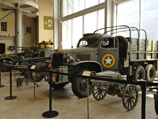
World War 2 Museum is a museum established in 2538 by Mr. Arun Monday a story collection. And supplies in the war to show the holdover. The exhibition is Art, Lahore. Outside the building, and the museum can see the remains of a steam locomotive. The inside with photos of historical evidence and the weapons of war in history.

There are also exhibits the history of Thailand. Since the war between Thailand and Burma There are collectibles such as antique silver sword bomb the Japanese fleet in World War 2, such as cars, motorbikes, boats and a three-dimensional model. Show event when the prisoners were enlisted to build a railroad. The well-being of prisoners of war. And the construction of a wooden bridge before moving to the present.

A trip to the Museum of World War 2.
Opposite the parking area at the bridge over the River Kwai. Across markets, jewelry and souvenirs. Five from the river about 200 meters.

- Is open to visitors daily from 7:00 to 18:30 hrs.
- Admission fee is 40 baht Thailand 20 baht for foreigners.
- For more information, 034-512-596


cave Krasae

cave Krasae


Details attractions:

Krasae Cave is a famous scenic spots. And is known as well. It is considered the most beautiful spots. And most dangerous of the Railway Central Falls - also known that. "Death Railway" (The Death Railway) on a daily basis, both in Thailand and foreign tourists frequented to view the Death Railway cave Krasae a lot for those who want to visit. Easily accessible by road and rail, because the cave Krasae also a railway station. Airport transfers for passengers

Krasae cave is located in Sai Yok district, a small cave located near the edge of the cliff railway. Former Prisoner of War Camp During the creation of the Death Railway Thailand - Burma Railway Centre in this regard. Is the most dangerous in railway construction. It is a way to cut through steep cliffs. The other side is a deep abyss into the river Kwai. During the route of about 400 meters with the difficulty of building a lot. Since the creation of this rail line. Since World War II Do not use modern equipment. There are only tools were a chisel hammer ax, a shovel, a wooden structure. With a tough construction environment. Coping with disease And food shortages It's a tragedy of war Where workers and prisoners have died. Tens of thousands of people during the railroad through this cave Krasae.

To really experience the Death Railway. The train journey When the train passed the station before the cave Krasae. The train will slow down For safety The bridge structure is still the original wooden structure. And has a beautiful view. From the banks of the Kwai Yai River flowing below.

If arrive by car Walking the scenic route along the railway sleepers and can pay homage to the Buddha statue inside Krasae was also at the train station with shops selling souvenirs. And for many travelers

Recommended
- Krasae Cave Scenic Route to Route 2.
Route One is a coffee house at about 4 kms wrote Krasae Bridge Caverns is 12 km to the park adjacent to the hotel Downtown. This area is far from the cave Krasae station and more. Walking on train tracks may be inconvenient.
Another path For anyone who wants seam Krasae And scenic spots as the Death Railway. Krasae cave to the station. Situated approximately 10 kilometers away.
- Route from the 323 junction to Sai Yok district has a steep downhill. Use a low gear
- Station cave Krasae Drive to visit this scenic spot. There is a parking place near the store.
- Visitors can walk around the scenic railroad ties and bridges. Noi river
- Be careful when walking on the tracks not playing, teasing, pushing, or climbing escapades around the track. It may be dangerous


Death Railway (The Death Railway).

Death Railway Is Railway of Thailand - Myanmar built during World War 2, the Japanese government would take steps to cut routes from Thailand. To connect with the railway in Burma. Ultimately, the strategic path is to settle down when Japan lost the war. But some rail Remain as a memorial to the brutality of war.

Railway was built in 2485, starting from catfish ponds. Ban Pong Ratchaburi Province Via Kanchanaburi In order to break into the city abreast of worship stuffed Myanmar with a total distance of 415 km, with the distance in approximately 303 km in Myanmar 111 km, the Japanese the prisoners of war from many countries, around 60,000 people, including workers employed. hundreds of thousands of other Asians Help build the railway to be completed within a period of five years, but with many obstacles. The difficulty of accessing the area is dense forest. Both ailments Food shortage during the war And workers at risk in the area is rocky, and the rush to build. Making prisoners and workers employed thousands of people have died. G-d, comparable to the rail route is the path that brought death to many people. It is the source of the word. "Death Railway"

Railway Thailand - Burma was completed earlier than the scheduled time. He spent only one year at a stretch of railway line to the border of Myanmar. It has tens of thousands of prisoners of war. And hundreds of thousands of Asian workers fell down. After the war ended in 2488, Japan announced the surrender of war. Rail line built to become the property of the British. The Allied war The rail line will be located in time. Thailand's government at that time to be redeemed with a price of 50 million baht in the custody of the State Railway of Thailand. To make repairs Bus station and open to the fish pond. Ratchaburi Province Until Coaches Kanchanaburi

Current railway station in Kanchanaburi Until terminal Falls about 77 km route through the beautiful scenery along the route. Especially near the bridge over the River Kwai. And the mortality curve Or cave Krasae Which became a tourist rail routes worldwide attention. This route and visit throughout the year.


Jeath War Museum

Jeath War Museum


Details attractions:


Jeath or JEATH War Museum is well known for foreigners who come to Kanchanaburi. The museum is the first exhibition tells the story of World War II. The prisoners of war had been taken to build the Death Railway. The museum is foreign to many viewers attention.

The museum has an unimpressive. The museum is open to visitors since July 24, 2520, inside the museum. Exhibits well-being Prisoners of war and hardship to build the Death Railway.

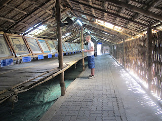
The museum features A U-shaped The entrance way And went the other way. Create a one-storey house with a thatched bamboo huts. To convey the feeling of walking into a POW camp. During that must endure hardship to build the Death Railway. Inside the cabin corridor Displaying pictures and paintings Subtitles along the well-being of those prisoners of war. And the history of World War II.

Building exterior display tools, such as the Japanese Army kettle, swords, firearms container field remains bombs found after the war.

JEATH word is the name of the museum. Comes from the first letter of each country that is involved in building railway lines, including Japan (Japan), English (England), Australia (Australia) Thailand (Thailand) and Holland (Holland) to commemorate those who have sacrificed their lives. Tens of thousands in the Pacific War. And the impact of the cruelty of war. As a result, those who fall under a prisoner of war. Was tortured both physically and mentally. Including the difficulty of forced labor at the time.

Traffic and contact information
- The museum is open daily from 8:00 am. -18.00.
- Admission fee is 30 baht Thailand 10 baht for foreigners.
- Ask for more information at 034-511-263

Recommended
- War Museum Jeath Wat Chai Chumphon win (the South) is. With constituents Museum of World War 2 (near the bridge).

A trip to the museum Jeath.
- From the street Sangchuto (The main road into the town of Kan) past three traffic lights being pigeonholed. Ran for about 400 meters and turn left at the signpost to the War Museum for another 300 meters to the end of the museum. (Next door) is available in a left hand.


Kanchanaburi War Cemetery

Kanchanaburi War Cemetery


Details attractions:


Kanchanaburi War Cemetery The locals affectionately known "British Gulag" or "Western Cemetery" is a monument open to visitors. To commemorate those lost during World War II. Especially foreigners who are prisoners of war at that time. Kanchanaburi War Cemetery Street Sangchuto Muang Kanchanaburi opposite the train station.

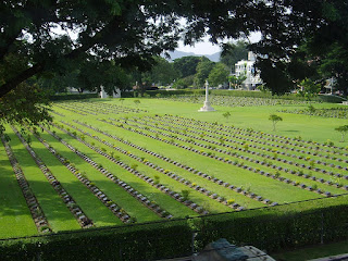
Kanchanaburi War Cemetery The cemetery was built in 2488 after World War II ended. An area of ​​about 17 acres of area residents dedicated to the burial of prisoners of war, some soldiers who died during the construction of the railway from Kanchanaburi to Myanmar. Kanchanaburi War Cemetery Is one of several The graves of those who died in the railroad property. The cemetery contains the graves of 6982 pitted the bodies of foreigners. The prisoners Villagers are affectionately known British cemetery, but it does not mean that this cemetery are only Anglican body. There are also prisoners from other countries such as the United Kingdom and Australia.

Cemetery space decorated in a wide open area. It's basically a lawn planted trees and flowers surrounding area graves are engraved name plaque age of the deceased. And the memorial to the deceased The surrounding property has been beautifully maintained and clean. The visiting Or would like to write an elegy Walking in the corridor between the graves.
Every April 25 of each year Anzac Day is the day the Australian government. A ceremony to commemorate the deceased. War events There lay a wreath to the memorial and stood in silence to mourn.

Within the cemetery Building a railway museum Thailand - Burma is open to visitors from 9:00 to 17:00 pm. Admission is 120 baht and are not allowed to take pictures inside the museum.


Traffic and contact information
Kanchanaburi War Cemetery The museum is open every day Without any cost.
- Open from 8.00 - 17.00.
- For more information tel. 034-511-500.

A trip to Don Rak War Cemetery.
Kanchanaburi - Cemeteries 1.5 km
Cemetery - Kanchanaburi train station 300 meters.
Cemetery - the bridge four kilometers.

- The main road Sangchuto Road. (Highway 323) runs to City, Kan. Straight through the intersection in downtown Kan approximately 1.5 kilometers through a permanent Wararam (Wat Yuan), then to the cemetery on your left, next to the temple or opposite the railway station in Kanchanaburi.

Recommended
- Should visit a calm. Respect for property And those who have passed away
- Do not shoot, do not fit. Or pretending to tease burlesque cemetery.
- Do not walk over the grave.
- Do not make loud - running around the graveyard.
- Are not allowed to bring food - beverages Chanin eat.
- Do not allow any type of event within the cemetery.


Hellfire Pass Museum

Hellfire Pass Museum


Details attractions:


Hellfire Pass Museum Is a fascinating history of tourism in Kanchanaburi. The museum has exhibits about building the Death Railway. During World War 2 period from 2485 to 2488, with the slide of a multimedia exhibition showcasing equipment and tools of prisoners of war. The total assumes an open place at Hellfire Pass was the route to build a railway to Burma.

Hellfire Pass Memorial Museum is located at the Division of Agriculture. Troops from the town of Sai Yok district, Kanchanaburi, about 80 km drive along Highway 323 to Thong Pha Phum district. Observed when driving at Sai Yok Noi, about 20 kilometers to the museum will be on your left.

Museum exhibits inside the main building. The floor-mounted air conditioner The exhibition displays the photos, slides, videos that convey the brutality. Savagery of war By the prisoners were forced to build a railway line through the rainforest filled with dangers of malaria. Including difficulties War and famine Causing tens of thousands of prisoners had fallen down. Railway, it was insinuated that the route to take. One life per sleeper 'A life for every sleeper' Also inside the museum. The exhibit also includes tools clothe prisoners of war. And to create a So that while there were no tools. And more than just a hammer, chisel, drill, shovels, hammers, shovels and buckets to build a railroad.

Some of the exhibits are written to punish prisoners. Exhibit features a model of the living conditions of prisoners. The model prisoner while carrying sleepers in weedy wireless strength, no clothes to wear. There are only a loincloth wrapped underwear only. Food samples of prisoners it has only a small pile of rice. With pickled vegetables and dried fish Letters can be sent to relatives of prisoners. It is only printed achievement prisoners fill just that liveth.

The second part of the museum On the back of the museum The trail down to the Hellfire Pass. The actual area where prisoners have shared this path with difficulty. The path to the area with two Hellfire Pass route is the route that went into the gorge along the tracks. The other route is the route to walk up the stairs to the top of the gorge to watch him from the top down. Both routes take time to walk it. Was walking in the gorge takes about 1.5-2 hours of top exhausted and spent about 3-4 hours.

More information
Hellfire Pass or have known one. "Spacing Hell" (Hellfire Pass) The name comes from that. Those prisoners who work at night. Have a bonfire and torchlight run time. When the lights reflected people. Causing a flickering light as the flames of hell. Hellfire Pass Museum Open since April 25, 2542 by the collaboration from the Australian government to gather information. Build a museum The exhibition area is divided into two parts: the exhibits inside the building and walking the gorge at a place behind the building.

Hellfire Pass route It cut a path through the gorge, so that the rail route was blocked. It requires workers to drill him into the box. It takes a lot to build trails. The prisoners from countries such as Australia, Britain, Holland and prisoners from other countries. As well as tens of thousands of workers employed at the point of the drill hole is considered a hardship. Because while it is being filled with overgrown forests, backwoods ago. It is also a tool to work the old fashioned manual labor to dig a lot in the building. This area also has the rail line was built. There are remnants of old ties, scrap metal and chains on display to commemorate the atrocity. And losses from the war At this point, so many people came to mourn for the departed is seen periodically.

On April 25 of each year as Anzac Day (Australian and New Zealand Army Corps) Day or Veteran's Memorial Australia - New Zealand. There is a ritual to commemorate the soldiers who died in the war.

Traffic and contact information
- Is open Monday - Sunday 9:00 pm. 16.00 PM. Does not cost any traffic.
- Contact us at 034-531-347, 08-1754-2098, 08-1814-7564.

A trip to Hellfire Pass Museum.
Kanchanaburi - Hellfire Pass Museum 80 kilometers.
Sai Yok Noi - Hellfire Pass Museum 20 kilometers.
Hellfire Pass Museum - Sai Yok Yai, 20 km.

- Kanchanaburi Road Runner Sangchuto the main road over the railway to the intersection lagoons to grain. Turn left to the Sai Yok district. (Highway 323)
- Running through Sai Yok Noi for about 20 kilometers through the school Toei. Notice on the left A signpost to Hellfire Pass Museum. The Division of Agriculture

Recommended
- The authorities have described as a headphone access. Just pay a deposit of 200 baht per unit. There is a choice of languages, English, Japanese, German, Thailand can take to dial a number to hear an explanation at various points.
- Walking back to Hellfire Pass takes about 1-2 hours or more of listening to lectures at various points. Visitors should shift to the right
- A walk in the gorges and scenic trails are relatively steep. Some of the larger conglomerate. So be extra careful The case brought by the children.
- The area around the museum has been maintained very well. Tourists should not bring food, beverages, pet inside the museum. Or even in the trash is not defined.
- Due to a museum exhibit losses from the war. People who visit should be focusing on traffic. No fuss loudly mocked or any other action. That's disparage the place and the area as a memorial for the deceased.
- Strolls around the gorge. Do not write climb and walk out of the path.